Digital Twin Integration for Road Networks Using LiDAR and AI
What is Digital Twin Integration for Road Networks?
Digital twin integration for road networks refers to the process of creating a dynamic, data-driven virtual representation of physical road infrastructure. This digital model continuously updates using real-world data collected from advanced technologies such as mobile LiDAR scanners, laser profilers, and AI-powered imaging systems.
Unlike traditional static models, a digital twin allows engineers and asset managers to monitor road conditions, analyze defects, and simulate maintenance strategies in real time. This approach improves decision-making, reduces operational costs, and extends the lifecycle of road assets.
How GeoAI Enables Digital Twin Integration
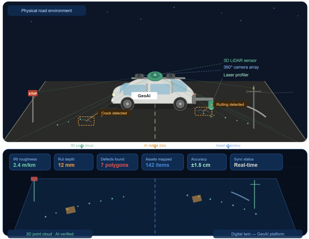
GeoAI combines multiple technologies into a single, integrated workflow to support digital twin integration for road networks. The technologies including mobile lidar and imaging system for asset imaging and laser profiler for surface analysis.
Mobile LiDAR and Imaging System
The system utilize Mobile LiDAR and imaging system to capture millions of data points per second, generating a precise 3D representation of the road and its surroundings. GeoAI deploys a mobile laser scanner equipped with:
- 3D LiDAR sensors for high-density point cloud capture
- 360-degree panoramic cameras for full visual coverage
- Planar cameras for detailed pavement and asset imaging
Laser Profiler for Surface Analysis
The laser profiler complements LiDAR data by providing detailed pavement performance measurements, including:
- Rutting depth
- Surface texture
- Road roughness (IRI)
These parameters are critical for pavement condition assessment and long-term maintenance planning.
AI-Powered Pavement Defect Detection
GeoAI integrates artificial intelligence to automate pavement inspection and enhance digital twin accuracy. The system uses AI to detect and classify:
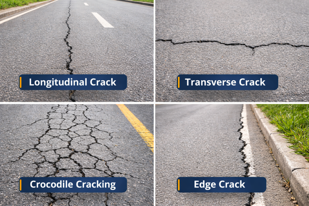
- Longitudinal and transverse cracks
- Crocodile (alligator) cracking
- Pump fines and surface deterioration
- Texture and roughness anomalies
A key innovation in GeoAI’s workflow is the combination of 2D AI detection with 3D LiDAR mapping.
First, AI models analyze high-resolution images to identify pavement defects. Then, the system maps these detected defects into the 3D point cloud. Finally, it generates precise 3D polygon representations of each defect. This process creates a spatially accurate dataset that forms the foundation of a reliable digital twin.
Road Asset Capture for Digital Twins
A complete digital twin requires more than pavement condition data. GeoAI captures all critical roadside assets in a single survey. These include:
- Traffic signs and signals
- Guard rails and safety barriers
- Power lines and utility poles
- Bus stops and street furniture
- Line markings and road geometry
Each asset is geo-referenced with centimeter-level accuracy and integrated into the digital twin environment.
Benefits of Digital Twin Integration for Road Networks
Digital twin integration for road networks provides significant advantages for infrastructure owners and operators.
- Real-Time Infrastructure Monitoring: Engineers can visualize road conditions and asset status in a single platform.
- Improved Maintenance Planning: Defect data and surface measurements help prioritize repairs and reduce costs.
- Data-Driven Decision Making: Accurate 3D data supports better planning, budgeting, and lifecycle management.
- Enhanced Safety and Compliance: Asset and defect mapping ensures compliance with safety standards and regulations.
- Support for Smart Cities: Digital twins enable integration with smart infrastructure systems and predictive analytics.
Applications in Australia’s Infrastructure Sector
In Australia, road authorities and infrastructure companies increasingly adopt digital twin integration to manage large and complex transport networks. Common applications include:
- Pavement condition surveys across highways and urban roads
- Asset inventory management for transport authorities
- Smart city infrastructure monitoring
- Construction verification and project handover
- Long-term infrastructure performance tracking
GeoAI provides tailored solutions for Australian conditions, ensuring accurate and scalable digital twin implementation.
Future of Digital Twin Road Networks
Digital twin integration will continue to evolve with advancements in AI, LiDAR, and cloud computing. Future systems will enable predictive maintenance, automated inspections, and real-time decision-making across entire transport networks.
By combining mobile LiDAR scanning, laser profiling, and AI-driven analysis, GeoAI delivers a future-ready solution for digital twin integration for road networks.
Frequently Asked Question (FAQ)
LiDAR captures high-density 3D point cloud data that forms the geometric foundation of a digital twin. It provides accurate measurements of road surfaces and surrounding assets.
AI automates defect detection, asset recognition, and data analysis. It enhances the digital twin by providing real-time insights and predictive capabilities.
A road digital twin requires 3D point cloud data, pavement condition data (rutting, roughness), asset inventory data, and high-resolution imagery.
Yes. Digital twins allow engineers to identify defects early, prioritize repairs, and optimize maintenance strategies based on accurate data.
Australia has large and complex road networks. Digital twin integration helps manage infrastructure efficiently, reduce maintenance costs, and support smart city initiatives.
Category List
- 3D Point Cloud
- Artificial Intelligence
- Asset Management
- Digital Twin
- Featured
- Hardware
- Knowledge Graph
- LiDAR
- News
- Site Monitoring
- Vegetation Monitoring
- Virtual Reality
Recent Post
- Digital Twin Integration for Road Networks Using LiDAR and AI
- Pavement Crack Detection using AI and LiDAR
- Pavement Defect Detection with GeoAI: Harnessing Laser Scanners and Profilers
- Asset Inventory Mapping with GeoAI: Complete Road Asset Capture Using Laser Scanning and Profiling
- Mobile Laser Scanner and Laser Profiler: Dual Approach to Road Surface Condition Surveys