Pavement Crack Detection using AI and LiDAR
What is Pavement Crack Detection?
Pavement crack detection is the process of identifying and mapping cracks in road surfaces to assess pavement condition and structural performance. Cracks often appear as early signs of pavement deterioration. If road authorities detect them early, they can repair the surface before the damage spreads and becomes more expensive to fix.
Traditional road inspections rely on manual surveys where engineers visually inspect pavement surfaces. These inspections often require significant time, traffic control, and large inspection teams. Modern technologies now allow engineers to automate pavement crack detection using artificial intelligence and mobile LiDAR systems.
Automated crack detection improves efficiency, increases accuracy, and enables agencies to inspect large road networks quickly.
Common Types of Pavement Cracks
Understanding different crack types helps engineers determine the severity of pavement damage and select the appropriate maintenance strategy.
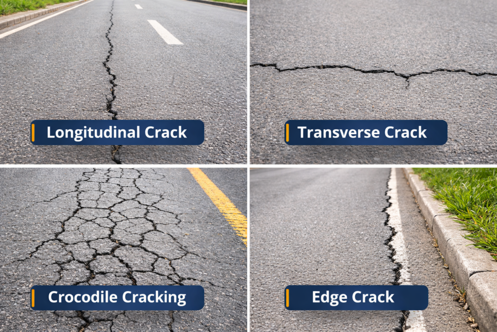
Longitudinal Cracks
Longitudinal cracks run parallel to the road centerline. These cracks often develop due to pavement fatigue, construction joints, or material shrinkage.
Transverse Cracks
Transverse cracks run perpendicular to the direction of traffic. Temperature changes and asphalt shrinkage commonly cause these cracks.
Crocodile Cracking (Alligator Cracking)
Crocodile cracking forms interconnected crack patterns that resemble reptile skin. This defect usually indicates severe structural failure in the pavement base and requires major rehabilitation.
Edge Cracks
Edge cracks appear near the outer edge of the pavement. Poor drainage, shoulder erosion, or weak pavement support typically causes this type of damage.
Traditional Pavement Crack Detection Methods
For decades, pavement crack detection relied primarily on manual inspections. Engineers walked along roads or drove slowly while visually recording defects. Although this approach provides basic information, it has several limitations:
- Inspections require significant time and labor
- Results may vary depending on the inspector
- Large road networks are difficult to inspect regularly
- Data often lacks precise spatial accuracy
Because of these limitations, many transportation agencies now adopt automated pavement inspection technologies.
AI Pavement Crack Detection
AI pavement crack detection uses machine learning algorithms to automatically identify cracks from road images. Survey vehicles equipped with high-resolution cameras capture images of the pavement surface while traveling at normal driving speeds. AI models then analyze these images to detect crack patterns and classify different defect types.
The system can automatically measure crack length, width, and severity. This automated process significantly reduces inspection time while improving consistency. AI detection also removes human subjectivity, ensuring that every road segment is evaluated using the same criteria.
Combining AI Detection with 3D LiDAR Mapping
GeoAI enhances pavement crack detection by combining 2D AI image analysis with 3D LiDAR mapping. This workflow provides both visual detection and spatial accuracy.
Step 1: 2D AI Crack Detection
High-resolution road images are processed using AI algorithms to detect pavement defects such as cracks, crocodile cracking, and surface anomalies.
Step 2: Mapping Defects into the LiDAR Point Cloud
Once AI identifies the defects, the system maps the detected crack boundaries into the LiDAR point cloud collected by the mobile laser scanner.
Step 3: Generating 3D Defect Polygons
The system then generates three-dimensional polygon shapes representing each detected defect. These polygons accurately define the location, geometry, and extent of the crack within the road network.
This process produces a spatially accurate defect map that engineers can integrate into GIS platforms, pavement management systems, or digital twin environments.
Benefits of Automated Pavement Crack Detection
Automated pavement crack detection provides significant advantages for road authorities and infrastructure managers.
Faster Inspections
Mobile survey vehicles can inspect large road networks at normal traffic speeds without disrupting traffic.
Higher Detection Accuracy
AI models detect cracks consistently and reduce the risk of missed defects.
Precise Geolocation
LiDAR and GNSS systems provide centimeter-level spatial accuracy for each detected defect.
Better Maintenance Planning
Engineers can prioritize repairs based on defect severity and location.
Digital Twin Integration
3D defect polygons integrate directly into digital infrastructure models, enabling advanced asset management and predictive maintenance.
Applications of Pavement Crack Detection
Pavement crack detection supports many transportation and infrastructure management tasks.
- Road surface condition assessment
- Pavement maintenance planning
- Infrastructure digital twin development
- Road asset management systems
- Contractor compliance and quality verification
- Long-term pavement performance monitoring
With growing infrastructure demands, automated pavement crack detection has become an essential tool for modern road management.
Frequently Asked Question (FAQ)
Early detection helps prevent small defects from developing into major structural failures. Detecting cracks early reduces repair costs and improves road safety.
AI pavement crack detection analyzes high-resolution images of the road surface using machine learning algorithms. The system automatically identifies crack patterns and classifies different defect types.
Combining AI and LiDAR enables engineers to map detected cracks into a 3D point cloud. This approach creates accurate polygon maps that show the exact location and size of each defect.
Modern AI and LiDAR systems can detect pavement cracks with high reliability and centimeter-level spatial accuracy depending on the survey equipment and processing methods.
Yes. Pavement crack detection data integrates easily with GIS systems, pavement management software, and digital twin platforms to support infrastructure planning and maintenance.
Category List
- 3D Point Cloud
- Artificial Intelligence
- Asset Management
- Digital Twin
- Featured
- Hardware
- Knowledge Graph
- LiDAR
- News
- Site Monitoring
- Vegetation Monitoring
- Virtual Reality
Recent Post
- Pavement Crack Detection using AI and LiDAR
- Pavement Defect Detection with GeoAI: Harnessing Laser Scanners and Profilers
- Asset Inventory Mapping with GeoAI: Complete Road Asset Capture Using Laser Scanning and Profiling
- Mobile Laser Scanner and Laser Profiler: Dual Approach to Road Surface Condition Surveys
- Edge Pavement Detection: Using LiDAR and AI for Road Asset Management