Pavement Defect Detection with GeoAI: Harnessing Laser Scanners and Profilers
Modern infrastructure management requires more than just visual inspections. Today, pavement defect detection powered by laser scanners and profilers is transforming how engineers identify and address issues in road networks. GeoAI offers a state-of-the-art solution by integrating mobile laser scanning, high-speed laser profiling, and artificial intelligence. Our aim is to deliver rapid, objective, and highly detailed pavement condition assessments.
How Does AI Pavement Defect Detection Work?
GeoAI’s survey vehicle combines a high-density mobile laser scanner, a laser profiler, and synchronised imaging systems. As the vehicle travels your road network:
- The mobile laser scanner collects millions of 3D points and panoramic images, mapping the pavement and surrounding features with centimeter-level accuracy.
- The laser profiler measures surface rutting, texture, and roughness with sub-millimeter precision
- We geo-reference all data streams and process it in real-time
After collecting the data, we analyze the entire dataset to automatically detect and classify:
- Transverse and longitudinal cracks
- Crocodile (alligator) cracking
- Pump fines and other surface defects
- Rutting depth, roughness, and texture variations
Result: a precise, GIS-ready defect map that eliminates human subjectivity and speeds up maintenance planning.
GeoAI Workflow for AI Pavement Defect Detection
A key innovation in GeoAI’s pavement defect detection process is our seamless integration of 2D AI detection and 3D point cloud mapping. Our workflow begins by running advanced 2D AI algorithms on high-resolution road images to identify and classify pavement defects, such as cracks, potholes, pump fines, and crocodile cracking.
Once the system detects defects in the 2D imagery, each defect’s boundaries and geometry are mapped directly into the 3D point cloud generated by our mobile laser scanner and profiler. This fusion enables us to assign a precise spatial location and shape for every defect, not just in two dimensions but as true three-dimensional polygons.
The result is a comprehensive, spatially accurate digital map of all detected pavement defects. For each feature, we generate a 3D polygon that can be used for volumetric calculations, surface modeling, or integration into GIS and asset management platforms.
Please see the images below for a real example from our workflow:
- The left image shows an overhead view of the road point cloud with detected features and defects outlined in green polygons, aligned to the road geometry.
- The right image shows the camera view, with the same defects overlaid on the original road image, confirming their shape and position.
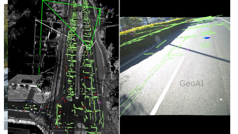
This innovative mapping approach ensures that every crack, pothole, or surface anomaly detected by AI is not only cataloged but is also precisely referenced in the 3D survey dataset. This provides engineers and asset managers with actionable information for targeted maintenance, lifecycle analysis, and digital twin modeling.
Why Choose AI-Driven Pavement Defect Detection?
- Unmatched speed: Inspect kilometers of road in hours, not days.
- Superior consistency: AI delivers repeatable, objective results with a small risk of missed or misclassified defects.
- Comprehensive data: Capture both surface defects and deeper pavement issues (e.g., rutting, roughness) in a single pass.
- Actionable outputs: Receive shapefiles, defect tables, heatmaps, and engineering-ready data for integration into your asset management or digital twin platform.
Potential Use Cases
- Prioritizing pavement maintenance and rehabilitation
- Compliance and warranty inspections for contractors
- Supporting digital twin models for infrastructure
- Monitoring pavement performance over time
- Documenting as-built road condition before and after major works
Frequently Asked Question (FAQ)
AI pavement defect detection is an automated process that uses artificial intelligence to identify and classify road surface defects such as cracks, crocodile cracking, rutting, and pump fines. The system analyzes high-resolution images and LiDAR data to detect defects quickly and consistently.
AI pavement defect detection combines 2D image-based deep learning with 3D LiDAR point cloud data. The AI first identifies defects from camera images. The system then maps each detected defect into the LiDAR point cloud to generate accurate 3D polygon representations with precise geo-location.
AI pavement defect detection can identify transverse cracks, longitudinal cracks, crocodile (alligator) cracking, rutting, surface texture anomalies, and pump fines. Advanced systems can also classify severity levels for maintenance prioritization.
AI pavement defect detection provides consistent and repeatable results with centimeter-level spatial accuracy when integrated with LiDAR. Unlike manual surveys, AI reduces subjectivity, minimizes missed defects, and processes large road networks efficiently.
Yes. AI pavement defect detection outputs can be delivered as GIS-ready shapefiles, CAD files, heatmaps, and defect tables. These datasets integrate directly into pavement management systems, asset management platforms, and digital twin models.
Combining 2D AI detection with 3D mapping enhances AI pavement defect detection by adding depth, spatial accuracy, and measurable geometry. This allows engineers to calculate defect areas, lengths, and even volumes. As a result, we can expect a better maintenance planning and budgeting.
Category List
- 3D Point Cloud
- Artificial Intelligence
- Asset Management
- Digital Twin
- Featured
- Hardware
- Knowledge Graph
- LiDAR
- News
- Site Monitoring
- Vegetation Monitoring
- Virtual Reality
Recent Post
- Smart City Infrastructure Monitoring for Civil Engineers Using LiDAR and AI
- Digital Twin Integration for Road Networks Using LiDAR and AI
- Pavement Crack Detection using AI and LiDAR
- Pavement Defect Detection with GeoAI: Harnessing Laser Scanners and Profilers
- Asset Inventory Mapping with GeoAI: Complete Road Asset Capture Using Laser Scanning and Profiling