Smart city infrastructure monitoring using LiDAR and AI helps civil engineers detect asset defects, manage road networks, and support data-driven urban planning in real time.
Smart city infrastructure What Is Smart City Infrastructure Monitoring?
Smart city infrastructure monitoring refers to the continuous, data-driven process of observing, recording, and analysing the condition of physical urban assets, including roads, bridges, signage, utilities, and drainage systems. For civil engineers, this process is foundational to maintaining safe, functional, and cost-effective urban environments.
Traditional monitoring relied heavily on manual inspections: field crews walking or driving routes, recording defects on paper or basic digital forms. This approach is slow, inconsistent, and expensive at scale. As cities grow and infrastructure ages, it simply cannot keep pace with the volume and complexity of assets that require attention.
Modern smart city infrastructure monitoring replaces this model with integrated sensor networks, mobile scanning platforms, and artificial intelligence. It enables civil engineers to capture, analyse, and act on infrastructure data faster and more accurately than ever before.
Why Civil Engineers Need Smart Infrastructure Monitoring
Civil engineers are responsible for the full lifecycle of urban infrastructure: planning, construction, inspection, maintenance, and renewal. Each of these phases depends on accurate, timely data about asset condition. Without it, engineers are forced to make decisions based on incomplete information. As a result, it leads to reactive maintenance, budget overruns, and preventable failures.
The global smart city ICT infrastructure market is valued at over USD 170 billion in 2025 and is projected to grow steadily over the next decade, driven largely by IoT and AI adoption. For civil engineers, this growth represents a direct investment in the tools they need to manage infrastructure more effectively.
USD 170B+
Smart city ICT market
±1.5 cm
Positional accuracy
1 pass
Full asset capture
Real-time
Digital twin sync
Core advantages for civil engineers
Proactive maintenance — Defects are detected before they become failures.
Data integrity — Survey data is spatially accurate and audit-ready.
Asset lifecycle extension — Track degradation trends over time.
How GeoAI Supports Smart City Infrastructure Monitoring?
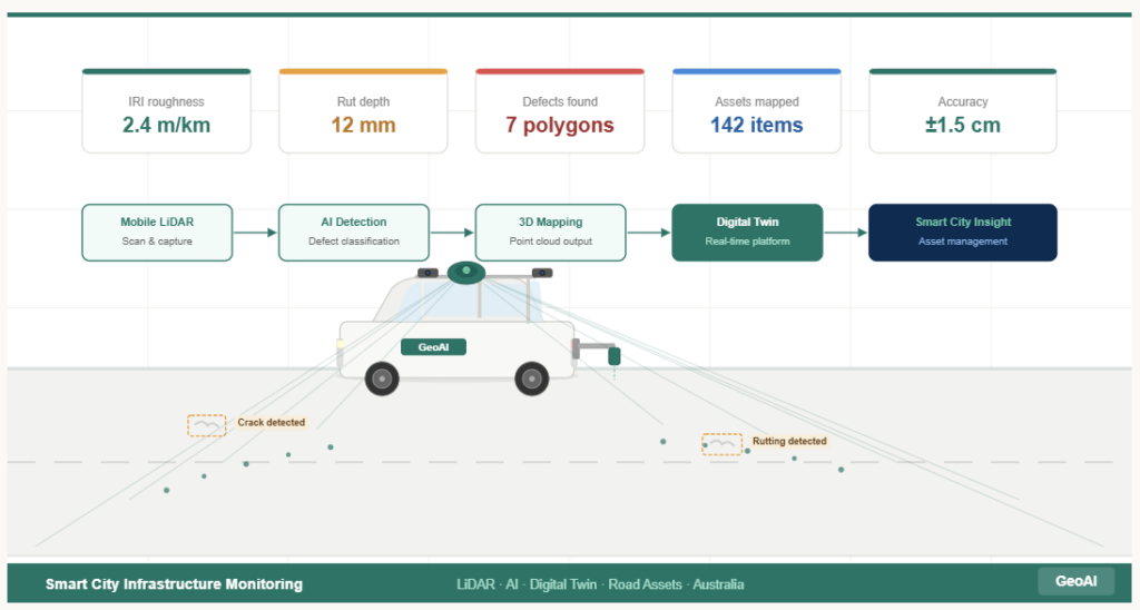
GeoAI delivers an end-to-end monitoring solution designed specifically for the demands of civil engineering practice. The system combines mobile LiDAR scanning, AI-powered defect detection, and digital twin integration into a single, scalable workflow.
scan & capture
AI detection
defect classification
3D mapping
point cloud output
Digital twin
real-time platform
Mobile LiDAR
scan & capture
AI detection
defect classification
3D mapping
point cloud output
Digital twin
real-time platform
Mobile LiDAR and Imaging Platform
GeoAI deploys a mobile scanning vehicle equipped with:
3D LiDAR sensors that capture high-density point clouds at millions of data points per second360-degree panoramic cameras providing full visual coverage of the road corridorPlanar cameras for detailed pavement and asset imaging at the surface level
This platform travels at standard traffic speeds. It means that data collection does not require lane closures or traffic disruption. This is a critical advantage for urban monitoring programmes.
Laser Profiler for Pavement Performance
Alongside the LiDAR system, GeoAI’s rear-mounted laser profiler captures pavement performance data including:
International Roughness Index (IRI) — the primary measure of ride quality and structural performanceRutting depth — a key indicator of pavement fatigue and load-bearing capacitySurface texture — relevant to skid resistance and drainage performance
AI-Powered Defect Detection and Classification
GeoAI integrates machine learning models trained on large infrastructure datasets to automatically detect and classify a wide range of defects, including:
Longitudinal and transverse cracking
Crocodile (alligator) cracking indicating structural failure
Pump fines and surface ravelling
Potholing and edge breaks
Texture loss and polishing
A key innovation in GeoAI’s workflow is the fusion of 2D AI detection with 3D spatial data. The AI first identifies defects in high-resolution imagery, then maps each detection into the 3D point cloud to generate precise polygon representations with real-world coordinates. This gives civil engineers spatially accurate defect records that can be directly integrated into asset management systems and GIS platforms.
Comprehensive Road Asset Capture
Smart city infrastructure monitoring requires more than pavement data. GeoAI captures all critical roadside assets in a single survey pass:
Traffic signs, signals, and line markings
Guard rails and safety barriers
Power poles and overhead utilities
Bus stops and street furniture
Kerbing, drainage inlets, and culverts
Road geometry and alignment data
Each asset is geo-referenced with centimetre-level accuracy and attributed with condition information, making the survey output directly usable for asset registers, maintenance schedules, and capital works planning.
Benefits of Smart City Infrastructure Monitoring for Civil Engineers
Reduced Inspection Costs
Mobile LiDAR surveys cover significantly more network per day than traditional foot-based or drive-by inspections, reducing the cost per kilometre of data collection while improving data quality and consistency.
Improved Safety
Removing inspectors from live traffic environments reduces exposure to road safety risk. GeoAI’s vehicle-mounted platform collects data from within the normal traffic stream, eliminating the need for traffic control or lane closures in most circumstances.
Regulatory Compliance
In 2026, infrastructure resilience is transitioning from isolated capital projects to a high-yield portfolio strategy, with local governments managing energy, water, and critical facility assets amid ageing infrastructure, budget shortfalls, and increasing climate risk. GeoAI’s survey outputs support civil engineers in meeting these governance requirements with defensible, auditable data.
Predictive Maintenance Capability
By establishing accurate baseline condition records and monitoring change over time, civil engineers can shift from reactive to predictive maintenance. As a result, we can address defects at the point of optimal intervention rather than after failure.
Scalability Across Networks
GeoAI’s platform is designed to scale from single road sections to entire municipal or state road networks, making it suitable for councils, state road authorities, and private infrastructure operators of any size.
Smart City Infrastructure Monitoring in Australia
Australia presents specific challenges for infrastructure monitoring: vast network extents, diverse climate zones, and a growing gap between infrastructure investment and maintenance funding. GeoAI is positioned to support Australian civil engineers with a purpose-built platform that addresses these challenges directly.
State and territory road authorities requiring network-wide condition data for funding submissions and maintenance programmesLocal governments managing ageing urban infrastructure with constrained budgetsInfrastructure delivery contractors providing as-built verification and handover datasetsTransport planning consultancies requiring accurate baseline data for corridor studies and feasibility assessments
The Future of Smart City Infrastructure Monitoring
Urban infrastructure monitoring is becoming increasingly data-driven, with advances in LiDAR, AI, and drone technology helping cities understand and manage their asset portfolios with greater accuracy and at lower cost than traditional ground surveys.
For civil engineers, this trajectory points toward a future in which infrastructure monitoring is continuous, automated, and fully integrated with digital twin platforms and smart city management systems. Predictive analytics will move from a leading-edge capability to a baseline expectation, and engineers who build competency in working with spatial data and AI-generated insights will be best positioned to deliver value in this environment.
GeoAI is investing in these capabilities now — developing the platform, the data pipelines, and the engineering workflows that will define smart city infrastructure monitoring in Australia for the decade ahead.
Why Choose GeoAI for Smart City Infrastructure Monitoring?
GeoAI combines industry-leading LiDAR hardware, purpose-trained AI models, and deep civil engineering domain knowledge into a monitoring solution that is accurate, efficient, and directly aligned with the needs of infrastructure managers and engineers.
What GeoAI delivers
Centimetre-accurate 3D point cloud data of road corridors and assets
Automated AI defect detection mapped to 3D spatial coordinates
Full road asset capture in a single survey pass
GIS-compatible outputs ready for immediate integration into asset management workflows
Scalable delivery across local, regional, and national road networks
Ready to bring smart city infrastructure monitoring to your next project? Contact GeoAI today.