LiDAR Road Survey Sydney: Mobile Scanning for Councils and Transport Authorities
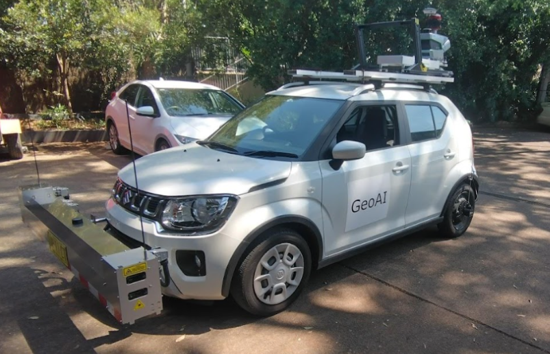
GeoAI delivers professional LiDAR road surveys across Sydney for councils and Transport for NSW projects. Our mobile scanning vehicle operates at normal traffic speed with no lane closures. In a single pass, it captures centimetre-accurate pavement condition data, road asset inventory, and 3D point clouds, all in a single pass.
Why Sydney Councils Need a LiDAR Road Survey?
Sydney manages one of Australia’s most complex urban road networks. In fact, Greater Sydney alone contains thousands of kilometres of local, regional, and state roads. As a result, councils must continuously assess pavement condition, maintain accurate asset registers, and justify maintenance budgets to the NSW Government every year. At the same time, community expectations for road safety and service quality continue to increase.
Traditional road inspection methods are often slow, labour-intensive, and expensive. Typically, a manual survey crew can inspect only a limited number of kilometres each day. Furthermore, results frequently vary between inspectors, making it difficult to produce consistent and auditable datasets across multiple survey programs. Consequently, these limitations create significant challenges for council engineers who require reliable and defensible data for funding submissions and long-term asset planning.
Specifically, a LiDAR road survey in Sydney solves these problems. GeoAI‘s mobile scanning vehicle covers entire road networks quickly. The data is accurate, repeatable, and ready for import into council GIS systems. Every asset and every pavement defect receives a GPS-referenced location.
The growing demand for faster road data in NSW
Importantly, Transport for NSW has recognised that faster and more affordable data collection enables safety assessments to occur annually across the entire road network. In addition, the federal government is increasingly linking infrastructure funding to measurable improvements in road safety and asset performance. Therefore, councils that can produce regular, evidence-based condition reports are generally in a stronger position to secure both state and federal funding opportunities.
For example, GeoAI’s mobile LiDAR platform makes annual surveying practical and scalable for Sydney councils of every size. Previously, only larger councils with substantial budgets could afford frequent condition assessments across extensive road networks. Now, the cost-per-kilometre of mobile LiDAR surveying makes it accessible to mid-size and smaller councils as well.
Traditional road inspection
- Requires lane closures and traffic control
- Small network coverage per day
- Inconsistent results between inspectors
- Safety risk for field crews
- Weeks to produce usable data
- Separate visits for assets and pavement
GeoAI LiDAR road survey
- No lane closures — surveys at traffic speed
- Entire Sydney networks surveyed quickly
- Consistent AI-automated results every time
- No field crew exposed to live traffic
- Data delivered within days of survey
- Assets and pavement captured in one pass
How GeoAI Conducts a LiDAR Road Survey in Sydney
GeoAI deploys a compact mobile scanning vehicle across Sydney’s road network. Importantly, the vehicle operates within normal traffic flow. It does not need traffic control or lane closures in most circumstances. This makes it practical for busy metropolitan roads where closures are disruptive and expensive to manage.
The GeoAI Scanning System
The vehicle carries a roof-mounted 3D LiDAR sensor that fires millions of laser pulses per second. Each pulse measures the precise distance to the surface it hits. As a result, the system builds a dense 3D point cloud of the entire road corridor in real time.
Alongside the LiDAR sensor, a 360-degree panoramic camera captures full visual coverage of the road corridor. Furthermore, a rear-mounted laser profiler measures pavement performance metrics as the vehicle travels. Specifically, all sensors collect data simultaneously, so nothing requires a second visit.
Mobile LiDAR scan
Millions of points/sec at traffic speed
AI classification
Points labelled by surface type
Defect detection
Cracks, rutting, potholes mapped
Asset extraction
Signs, poles, barriers captured
GIS Delivery
Council-ready spatial outputs
Category List
- 3D Point Cloud
- Artificial Intelligence
- Asset Management
- Digital Twin
- Featured
- Hardware
- Knowledge Graph
- LiDAR
- News
- Site Monitoring
- Vegetation Monitoring
- Virtual Reality
Recent Post
- Scan-to-BIM Workflow Explained: From LiDAR Point Cloud to BIM Model
- As-Built Drawing Survey Sydney: LiDAR Verification for Construction Projects
- Digital Twin for Construction Projects – How LiDAR Powers Real-Time Site Models
- Road Asset Management Sydney
- Pavement Condition Survey: AI-Powered Road Assessment for Local Councils
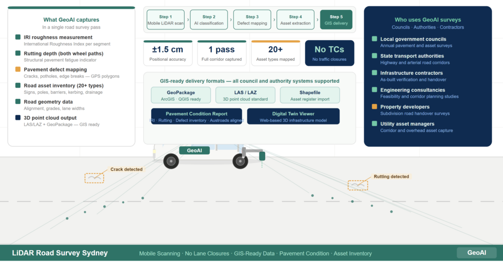
What GeoAI captures in a Sydney LiDAR road survey
A single survey pass captures a complete dataset for your road network. Consequently, nothing requires a second visit to the same road segment.
Data captured in every GeoAI LiDAR Road survey
- Rutting depth — measured across both wheel paths to detect structural pavement fatigue
- Surface texture — relevant to skid resistance and drainage performance on Sydney roads
- Pavement defects — longitudinal cracks, transverse cracks, crocodile cracking, potholes, and edge breaks, all mapped to GPS coordinates
- Road assets — traffic signs, signals, guard rails, power poles, kerbing, drainage inlets, bus stops, line markings, and road geometry
- Road geometry — horizontal alignment, vertical grade, lane widths, and carriageway dimensions
- 3D point cloud — a complete georeferenced spatial model of the road corridor
How AI improves defect detection accuracy
After the vehicle completes its scan, GeoAI’s AI models process the imagery automatically. First, the system identifies defects in high-resolution camera footage. Subsequently, each detected defect maps into the 3D point cloud with a GPS-referenced polygon. Finally, the result is a spatially accurate defect inventory that council engineers can query directly in GIS.
Compared to manual inspection, this approach is significantly more consistent. For instance, a manual inspector may classify a crack differently depending on lighting, fatigue, or experience level. In contrast, GeoAI’s AI model applies the same classification criteria to every defect across the entire network.
How GeoAI Data Integrates with Council GIS Systems
GeoAI delivers all survey data in standard geospatial formats. Every council uses ArcGIS, QGIS, or compatible asset management software. Importantly, GeoAI outputs import directly into these systems without custom integration work.
Standard delivery formats
- GeoPackage and Shapefile — compatible with ArcGIS and QGIS used by all NSW councils
- LAS and LAZ point cloud — the industry standard for 3D point cloud data in line with NSW Spatial Services specifications
- Pavement condition reports — IRI, rutting, and defect inventory formatted for direct input into pavement management systems
- Asset registers — geo-referenced asset lists ready for import into IPWEA-compliant council asset management databases
- Digital twin access — web-based 3D viewer for engineers to visualise road conditions and measure infrastructure remotely
TfNSW compatibility
TfNSW’s Digital Engineering Survey Requirements Guide specifies point cloud density, deliverable formats, and level of accuracy ranges for road survey projects. Accordingly, GeoAI’s survey outputs align with these requirements for contractors and agencies submitting data to TfNSW. In addition, all spatial data uses the Map Grid of Australia (MGA) coordinate system, which is the standard projection used across NSW for road and infrastructure projects.
Turnaround Time and Project Delivery
GeoAI delivers survey data within days of completing fieldwork. Generally, a typical council road network survey takes two to five business days to process after data collection. However, timelines vary depending on network size and deliverable format.
GeoAI provides a project timeline at the quoting stage. This timeline confirms fieldwork dates, processing time, and final delivery date. Local councils receive data in time for annual budget cycles and capital works programming.
What to expect after you engage GeoAI
First, GeoAI provides a confirmed project timeline at the quoting stage. This timeline includes fieldwork dates, processing time, and the final delivery date. Subsequently, fieldwork takes place within normal traffic flow at no disruption to road users. Finally, processed data arrives in your preferred GIS format, ready for import into council systems.
In addition, Sydney councils receive data in time for annual budget cycles and capital works programming. For example, councils that commission surveys in the first quarter of the financial year have condition data ready before budget submissions are due. As a result, funding requests are supported by current, auditable spatial data.
Frequently Asked Question (FAQ)
No. GeoAI’s mobile scanning vehicle operates within the normal traffic stream. In most circumstances, no lane closures or traffic control are required. This significantly reduces the cost and disruption associated with data collection on busy roads.
Yes. GeoAI delivers point cloud data and spatial outputs that align with TfNSW’s Digital Engineering Survey Requirements Guide. Data is delivered in formats compatible with TfNSW project submissions, including LAS point clouds and GeoPackage vector files referenced to the MGA coordinate system used across NSW.
Fieldwork duration depends on the total network length. Data processing and delivery typically takes two to five business days after fieldwork. GeoAI provides a confirmed project timeline at the quoting stage so councils can plan around budget and reporting deadlines.
GeoAI delivers International Roughness Index, rutting depth, surface texture, and a full pavement defect inventory. Defects include longitudinal and transverse cracking, crocodile cracking, potholing, and edge breaks. Each defect receives a GPS-referenced polygon in the 3D point cloud.
Yes. GeoAI surveys all road types across Greater Sydney including new subdivision roads in Western Sydney growth corridors. The survey establishes a verified as-built baseline at handover. As a result, it can protect both the developer and the accepting council with a defensible spatial record of road condition at the time of transfer.
Ready to bring geospatial AI to your road infrastructure?