Geospatial AI for Infrastructure: How GeoAI Is Transforming Australia’s Road Networks
Geospatial AI is transforming infrastructure management across Australia. By combining LiDAR scanning, machine learning, and digital twin platforms, GeoAI delivers smarter, faster, and more accurate road asset monitoring for engineers, councils, and transport authorities.
What Is Geospatial AI?
Geospatial AI, often written as GeoAI, is the integration of artificial intelligence and machine learning with spatial data. It combines location-referenced datasets from sources such as LiDAR scanners, satellite imagery, GPS, and IoT sensors with AI algorithms that can classify, detect, predict, and analyse geographic features automatically.
Where traditional geospatial analysis required skilled professionals to manually interpret maps and survey data, geospatial AI automates this interpretation at scale. AI models trained on labelled spatial datasets can identify roads, buildings, vegetation, infrastructure assets, and surface defects with expert-level accuracy. It can process hundreds of kilometres of data in hours rather than weeks.
In the infrastructure sector, geospatial AI is rapidly becoming the foundation of modern asset management. Engineers and transport authorities use it to monitor road conditions, detect pavement defects, map roadside assets, and build digital twin environments that mirror physical infrastructure in real time.
Why Geospatial AI Matters for Australian Infrastructure
Australia faces a unique set of infrastructure challenges: vast road networks spread across diverse climates, an aging asset base, constrained maintenance budgets, and growing demand from state and federal authorities for evidence-based asset management decisions.
The Australian Government’s National AI Plan, released in December 2025, identifies AI and advanced geospatial capability as central to the country’s long-term prosperity and security. Australia’s future of infrastructure is being redefined by AI-powered design, immersive digital twins, and open geospatial platforms.
For civil engineers and infrastructure managers, geospatial AI addresses the core operational problem: getting accurate, timely data about the condition of assets across large networks, without the cost and safety risks of traditional manual inspection.
Three reasons geospatial AI is essential for Australian infrastructure
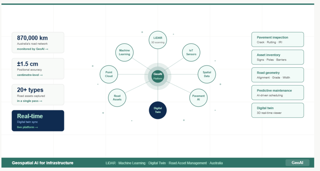
- Scale — Australia’s road network spans over 870,000 km. Manual inspection at this scale is logistically and financially impossible. Geospatial AI enables continuous, automated monitoring across entire networks.
- Accuracy — AI models trained on Australian road data detect defects, classify assets, and measure surface conditions with sub-centimetre precision — far exceeding what manual inspectors can consistently achieve.
- Speed — Mobile LiDAR combined with AI processing reduces survey-to-report time from weeks to days, enabling faster maintenance decisions and more responsive asset management.
How GeoAI Applies Geospatial AI to Road Infrastructure
GeoAI is an Australian geospatial AI company specialising in road network monitoring, asset capture, and digital twin integration. The GeoAI platform combines mobile LiDAR scanning, AI-powered analysis, and 3D spatial data delivery into an end-to-end workflow purpose-built for infrastructure engineers.
Mobile LiDAR scan
Millions of points/sec
AI classification
Points labelled by type
Defect detection
Cracks, rutting, potholes
3D point cloud
GIS-compatible output
Digital twin
Real-time platform
Mobile LiDAR Scanning
GeoAI deploys a mobile scanning vehicle capable of operating at normal traffic speeds without lane closures or disruption. The vehicle carries a roof-mounted 3D LiDAR sensor that fires millions of laser pulses per second, recording the precise distance and reflectivity of every surface it encounters. Combined with 360-degree panoramic cameras and a rear-mounted laser profiler, the system captures a complete spatial record of the road corridor in a single pass.
AI-Powered Point Cloud Classification
The raw output of a LiDAR scan is an unstructured 3D point cloud. It is a dense dataset of millions of georeferenced points. GeoAI’s AI models, built on deep learning architectures trained on Australian road environments, classify every point into semantic categories: road surface, kerb, pavement marking, sign, pole, barrier, vegetation, and more.
This classification process (usually required weeks of manual labelling) is completed automatically. The AI adapts to the asphalt types, surface materials, and defect patterns common in Australian conditions, making it significantly more accurate than generic international models.
Automated Defect Detection
GeoAI’s system uses a two-stage approach: AI models first identify defects in high-resolution imagery, then map each detection into the 3D point cloud to generate precise polygon representations with real-world GPS coordinates. The system detects and classifies:
- Longitudinal and transverse cracking
- Crocodile (alligator) cracking indicating structural failure
- Potholing and edge breaks
- Rutting and surface deformation
- Pump fines and surface ravelling
- Texture loss and skid resistance deterioration
Digital Twin Integration
GeoAI’s survey data forms the spatial backbone of a digital twin. It is a live, continuously updated virtual replica of the physical road network. Engineers and asset managers access this environment through GeoAI’s 3D Digital Twin Viewer, visualising road conditions, asset locations, and defect distributions across the network in real time.
“GeoAI’s pipeline blends geospatial intelligence with machine learning: our AI models classify points into ground, pavement, vegetation, and built assets. The resulting data is hosted on GeoAI’s digital twin platform, enabling users to visualise, measure, and analyse infrastructure condition in real time”
Geospatial AI Applications in Australian Road Networks
Pavement Condition Surveys
State and local road authorities can use GeoAI‘s platform to conduct network-wide pavement condition surveys. The system captures International Roughness Index (IRI), rutting depth, and surface texture data alongside full visual records. We can deliver a complete pavement condition dataset that feeds directly into pavement management systems and budget planning tools.
Road Asset Inventory
Geospatial AI enables automatic extraction of more than 20 road asset types from a single LiDAR survey pass. Traffic signs, guard rails, power poles, bus stops, drainage inlets, kerbing, and line markings are all detected, classified, and geo-referenced with centimetre accuracy. As a result, we can eliminate the need for separate asset inventory surveys.
State-Specific Road Monitoring
GeoAI operates across Australian states and territories, with particular demand in Victoria and New South Wales. LiDAR surveys in NSW support transport authorities, local councils, and infrastructure contractors with accurate, current condition data for planning and maintenance programming.
Construction Verification and Handover
Geospatial AI is increasingly used for construction verification. We can compare as-built road geometry against design specifications using LiDAR-derived 3D models. GeoAI surveys at project handover establish a verified baseline condition record that protects both developer and authority, documenting exactly what was built and in what condition.
Predictive Maintenance
By comparing sequential LiDAR surveys, GeoAI’s AI models detect change over time. We can identify assets or road segments where deterioration is accelerating. Even a few centimetres of surface deformation detected early can prevent far more costly structural failure, shifting infrastructure management from reactive to predictive.
The Technology Behind GeoAI’s Geospatial AI Platform
LiDAR
LiDAR (Light Detection and Ranging) generates precise 3D geometry of every surface it encounters, independent of lighting or weather conditions. At highway speeds, GeoAI’s scanner delivers up to 400 points per square metre — sufficient density to detect minor surface cracks and measure deformation to sub-centimetre precision.
Deep learning for point cloud analysis
GeoAI’s AI models use deep learning architectures, including convolutional neural networks (CNNs) and point-based networks trained on large, labelled datasets of Australian infrastructure. This approach were used to classify LiDAR point clouds automatically. Intensity-based classification allows the AI to differentiate asphalt, concrete, and gravel surfaces by their distinct laser reflectivity patterns.
Machine learning for defect classification
Defect detection combines image-based machine learning with 3D spatial data. AI models trained on thousands of labelled examples of Australian road defects identify crack type, severity, and extent from high-resolution camera imagery, then fuse this with LiDAR geometry to produce spatially accurate 3D polygon representations of every detected defect.
GIS-compatible output
All GeoAI outputs are delivered in standard geospatial formats such as GeoPackage, Shapefile, and GeoJSON. It can compatible with ArcGIS, QGIS, and major asset management platforms. Engineers can import GeoAI survey data directly into their existing workflows without custom integration work.
Benefits of Geospatial AI for Infrastructure Engineers
What geospatial AI delivers for engineering teams
- Centimetre-accurate 3D point cloud data of road corridors and all visible assets
- Automated defect detection with GPS-referenced polygon mapping
- Full road asset inventory captured in a single survey pass
- GIS-compatible outputs ready for immediate integration into asset management workflows
- Scalable delivery from single road sections to entire state networks
- Reduced inspector exposure to live traffic — improved safety for field teams
- Repeatable, auditable survey methodology — defensible data for funding submissions
The Future of Geospatial AI in Australian Infrastructure
Geospatial AI is moving from a specialist capability to a baseline expectation in infrastructure management. As LiDAR hardware becomes lighter and more affordable, and as AI models continue to improve on Australian-specific training data, the gap between geospatial AI and traditional survey methods will only widen.
GeoAI is already developing the next generation of capability. Our strategy is to combine temporal LiDAR data with machine learning to build predictive models of infrastructure health that alert asset owners before visible damage occurs. Automatic detection of potholes, edge failures, and surface deformation from sequential scans feeding directly into maintenance schedules is not a future vision, it is already underway in GeoAI’s research and field programmes.
Ready to bring geospatial AI to your infrastructure programme?
Category List
- 3D Point Cloud
- Artificial Intelligence
- Asset Management
- Digital Twin
- Featured
- Hardware
- Knowledge Graph
- LiDAR
- News
- Site Monitoring
- Vegetation Monitoring
- Virtual Reality
Recent Post
- Scan-to-BIM Workflow Explained: From LiDAR Point Cloud to BIM Model
- As-Built Drawing Survey Sydney: LiDAR Verification for Construction Projects
- Digital Twin for Construction Projects – How LiDAR Powers Real-Time Site Models
- Road Asset Management Sydney
- Pavement Condition Survey: AI-Powered Road Assessment for Local Councils