Digital Twin for Construction Projects – How LiDAR Powers Real-Time Site Models
A digital twin construction project manager can trust is no longer a futuristic concept. Today, GeoAI uses mobile LiDAR scanners to build a live, evolving replica of your site. The data is updated throughout the entire project lifecycle. This article explains what a construction digital twin is, how GeoAI builds one scan at a time, and how one site used it to catch a costly earthwork error before it became a budget blowout.
What Is a Construction Digital Twin?
A construction digital twin is a precise, data-rich 3D replica of a physical building site. It mirrors the real site in near real time. Furthermore, it evolves as the project does. The model can store information from the first earthwork cut through to final handover.
Importantly, a digital twin is not a static 3D model. In contrast to a BIM model, which represents design intent, the digital twin represents physical reality as it exists right now. Therefore, when we compare these two datasets, discrepancies become visible immediately.
Why “Live” Is the Key Word
The live nature of a construction digital twin is what separates it from every other survey product. A traditional survey delivers a snapshot. A digital twin, however, delivers a continuously updated record. As a result, project managers can track how the site changes week by week. They can also identify drift from design before rework costs accumulate. Consequently, project teams can make informed decisions earlier. For construction projects where labour costs are high and programme delays are expensive, this real-time visibility offers genuine commercial protection.
For example, a construction digital twin can combine multiple data sources into a single environment. These may include LiDAR point clouds, BIM models, drone imagery, site photographs, earthwork volumes, concrete pour records, survey control points, progress percentages, RFIs, defect registers, and construction schedules. As a result, project teams can view both physical site conditions and project information from a single source of truth.
How GeoAI Builds a Digital Twin Construction Sydney Site Needs
GeoAI uses vehicle-mounted and handheld mobile LiDAR units to capture the site. Each scanner emits millions of laser pulses per second. These pulses return to the sensor and generate a dense, georeferenced point cloud. By using our Lidar, we can capture the entire site, including structures, plant, formwork, and terrainin a single pass.
From Raw Scan to Usable Twin
After capture, GeoAI processes the raw point cloud data. First, the data is cleaned, registered, and georeferenced to a known coordinate system. Next, AI-assisted classification separates ground, structure, and temporary works. Finally, the processed twin is delivered via a web-based viewer or exported for BIM integration.
This process typically completes within 24 to 48 hours of on-site scanning. Consequently, project managers receive updated intelligence almost immediately after each site visit.
What GeoAI captures in a single LiDAR site scan
- Terrain and earthwork volumes up to ±10 cm accuracy
- Structural concrete and steel framing positions
- Formwork, scaffolding, and temporary works in place
- Underground service pit locations where accessible
- Site access roads, compound layouts, and stockpile positions
How the Digital Twin Evolves Through the Project Lifecycle
Most people describe a digital twin as if it is a one-time deliverable. However, in reality, a construction digital twin has no single delivery date. Instead, it is a living record that grows richer with every rescan. GeoAI structures the update cadence around project phases.
For example, scans may be performed weekly during bulk earthworks, fortnightly during structural construction, and monthly during fitout activities. As a result, the digital twin continuously reflects changing site conditions rather than a single point in time. Moreover, every new scan becomes part of a historical record that allows project teams to compare progress, identify deviations, and track site evolution throughout the project lifecycle. Consequently, managers can see not only the current state of the project but also how conditions have changed over days, weeks, and months. Ultimately, this creates a single source of truth that supports decision-making from initial earthworks through to final handover and asset management.
Earthworks
Weekly scans track cut/fill volumes
Structure
Fortnightly scans verify slab and column positions
Exterior
Final twin becomes the as-built record
Interior
Monthly or fortnightly scans for services and finishes
Handover
Final twin becomes the as-built record
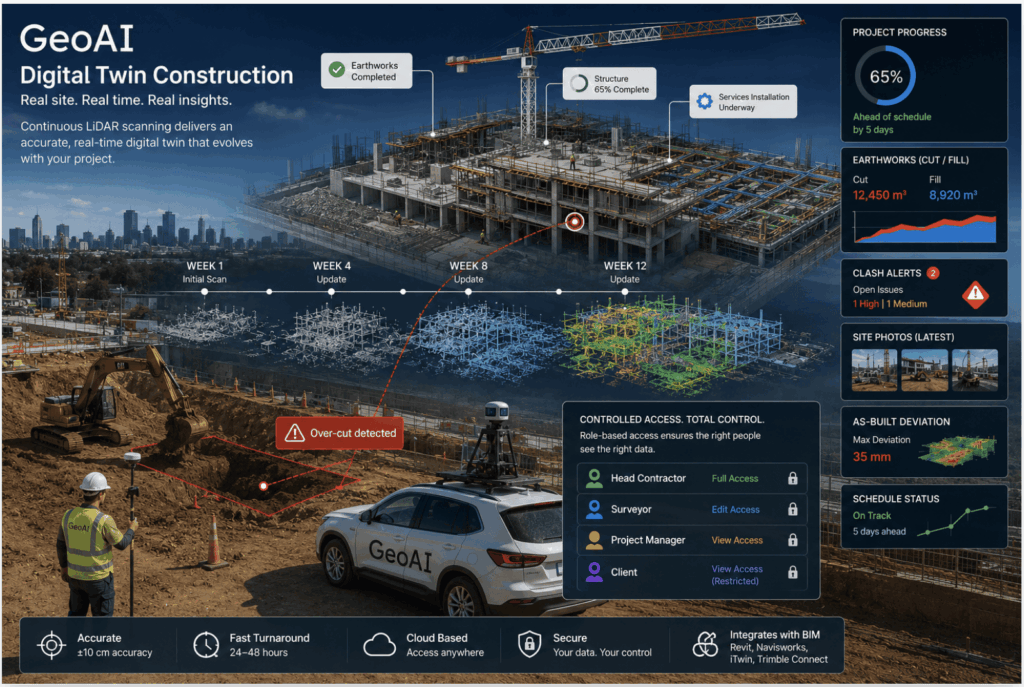
Site Example: How the Twin Caught an Earthwork Over-Cut
The following example illustrates the practical value of a live construction digital twin. Specifically, it reflects the type of scenario GeoAI’s scanning methodology is specifically designed to intercept.
RESIDENTIAL DEVELOPMENT — EARTHWORKS PHASE
During the bulk earthworks phase of a multi-level residential project, GeoAI can perform weekly rescan. The updated twin was compared automatically against the approved earthworks design model.
By utilizing GeoAI’s Digital Twin Dashboard ability to calculate the volume of earthwork, some data collected. The comparison flagged a 340 mm over-cut across an approximately 80 m² section of the basement floor. The excavation subcontractor had followed an earlier, superseded design file. Meanwhile, the current approved model set a higher finished floor level for that zone. The project manager can flagged and put comments to the Digital Twin Dashboard so all the team aware of the problem.
Because the digital twin comparison happened before the blinding concrete pour, the project team had three options: fill and compact the over-cut, adjust the footing design, or seek a design variation. The contractor chose a compacted fill solution. The cost was modest. Had the error been discovered at the slab inspection stage, the rectification would have required breaking out already-poured concrete with a significantly larger expense.
The twin paid for multiple months of scanning in a single early detection.
Applications of a Construction Digital Twin on Sydney Projects
A live digital twin supports multiple workflows across the construction programme. Importantly, its greatest value is the ability to run all of these workflows in parallel from a single, consistent dataset.
Site Progress Tracking
Each rescan produces a timestamped version of the twin. Project managers can scroll back through the version history. Consequently, they can show a principal or developer exactly how much physical work was completed during any period. For example, this capability is particularly useful for milestone-based payment claims.
Read more about Site Progress Monitoring
Clash Detection in the Physical World
Design clash detection is normally completed in BIM software before construction begins. However, GeoAI’s digital twin enables clash detection in the as-built environment. For example, a mechanical services run installed 120 mm higher than the BIM model can be detected before the ceiling is closed. As a result, rectification occurs during fitout rather than after costly demolition.
Stakeholder Reporting
Investors, owners, and financiers increasingly expect visual progress evidence. GeoAI can generate fly-through renders and annotated progress images directly from the twin. Moreover, these outputs require no additional survey visits because they originate from the same dataset used for technical quality control.
As-Built Verification
At handover, the final rescan produces a point cloud record of the completed building. This record supports occupation certificate applications and provides the asset owner with a verified spatial baseline for future facilities management.
Integration with BIM Workflows
GeoAI’s digital twin data integrates cleanly with existing BIM platforms. Deliverables are available in formats compatible with Autodesk Revit, Navisworks, Bentley iTwin, and Trimble Connect. Therefore, your BIM coordinator can overlay the real-world twin against the design model without a change to existing software.
Without a digital twin
- Manual set-out checks on selected points only
- Discrepancies found late
- Progress evidence relies on photos and RFIs
- As-built is compiled from memory at handover
- Subcontractors dispute scope with no spatial record
With GeoAI digital twin
- Whole-site verification after every rescan
- Discrepancies flagged before the next pour
- Progress evidence is spatial and timestamped
- As-built grows automatically through the project
- Spatial record resolves scope disputes objectively
Moreover, because the twin is georeferenced to a consistent coordinate system from day one, every rescan aligns with every previous scan. Consequently, cumulative drift analysis is possible across the full project timeline.
Data Ownership and Access Permissions Across Your Project Team
How GeoAI handles data ownership and access
- The client owns the data. All point cloud files and processed outputs belong to the head contractor or project owner from the moment they are delivered.
- Tiered access is available. GeoAI can configure platform access at three levels: read-only for subcontractors, measurement-enabled for site engineers, and full export rights for the head contractor and owner.
- Subcontractors see only their scope. A façade subcontractor can access the envelope scans without viewing structural data relevant only to the civil contractor. This protects commercially sensitive information across the project team.
- GeoAI does not retain or resell project data. Scan data is stored securely during the project and transferred to the client at practical completion. No data is used for training, benchmarking, or shared with third parties.
- Data sharing for principal review is available via read-only web viewer links. No software installation required by the principal’s team.
In practice, defining data access tiers at the start of a project prevents disputes later. Furthermore, it ensures subcontractors cannot inadvertently access or modify data that falls outside their contractual scope.
Deliverable Formats from a GeoAI Construction Digital Twin
GeoAI tailors deliverable formats to the way your project team actually works. Standard outputs include the following.
Start Your Construction Digital Twin Today
GeoAI can mobilise for an initial site scan and present your first digital twin within 48 hours of capture. Talk to our team about your project programme, site size, and preferred deliverable format.
Category List
- 3D Point Cloud
- Artificial Intelligence
- Asset Management
- Digital Twin
- Featured
- Hardware
- Knowledge Graph
- LiDAR
- News
- Site Monitoring
- Vegetation Monitoring
- Virtual Reality
Recent Post
- Scan-to-BIM Workflow Explained: From LiDAR Point Cloud to BIM Model
- As-Built Drawing Survey Sydney: LiDAR Verification for Construction Projects
- Digital Twin for Construction Projects – How LiDAR Powers Real-Time Site Models
- Road Asset Management Sydney
- Pavement Condition Survey: AI-Powered Road Assessment for Local Councils