Road Asset Management Sydney
Road asset management in Sydney demands accurate data, consistent methodologies, and connected digital systems. In particular, Greater Sydney’s road network spans thousands of kilometres and supports millions of residents, freight operators, public transport users, and emergency services every single day. As the city continues to grow, councils must manage increasingly complex infrastructure networks while maintaining high service standards for the community.
At the same time, councils face growing pressure to deliver safe, reliable, and well-maintained roads while carefully controlling lifecycle costs and operational budgets. In addition, ageing infrastructure, rising traffic volumes, and tighter funding constraints make long-term planning even more challenging. Consequently, councils need dependable and up-to-date asset information to prioritise maintenance and renewal activities effectively.
However, without complete and current asset data, maintenance budgets can easily be misallocated, renewal programs may fail to target the highest-risk areas, and critical defects can remain unnoticed for too long. As a result, operational inefficiencies increase, infrastructure deteriorates faster, and communities ultimately pay the price through reduced road safety, higher repair costs, and declining service quality. Therefore, accurate and integrated asset data is essential for smarter, more proactive road asset management across Sydney.
GeoAI changes the equation. Our mobile LiDAR platform can captures more than 20 road asset types in one survey pass. We deliver structured data that loads directly into IPWEA asset registers and council GIS systems. As a result, our platform can deliver the result faster than traditional procedure.
What Road Asset Management Involves?
Road asset management is the systematic process of planning, acquiring, operating, maintaining, and renewing road-related infrastructure. It covers the pavement itself and everything beside, above, and below it. For NSW councils, IPWEA’s International Infrastructure Management Manual (IIMM) sets the standard. It requires a comprehensive asset register, regular condition assessment, demand modelling, and long-term funding plans.
Core Activities
- Asset inventory — Knowing what assets exist, where they are, and their current condition.
- Condition assessment — Grading each asset against defined criteria on a 1–5 scale.
- Lifecycle costing — Calculating the cost to maintain, renew, or dispose of each asset.
- Renewal planning — Scheduling capital works based on condition and risk data.
- Financial reporting — Providing defensible valuations under AASB 116 for annual statements.
Every step depends on the quality of the underlying asset data. Councils that invest in accurate inventory make better decisions at every subsequent stage.
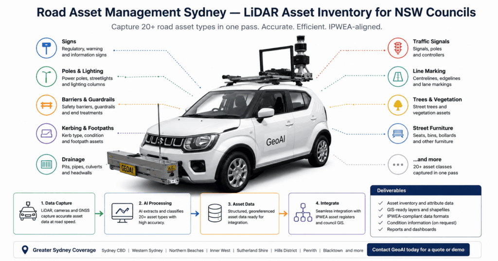
How GeoAI Captures 20+ Asset Types in One Pass
Traditional surveys are often slow, expensive, and incomplete. In many cases, councils must organise multiple site visits and deploy different crews to capture different asset classes. Furthermore, the collected information frequently requires weeks of manual processing and data entry before it can be used operationally. As a result, asset registers can quickly become outdated or inconsistent across departments.
By contrast, GeoAI delivers a faster and more integrated approach. Instead of relying on multiple field teams, our mobile LiDAR vehicles drive each road segment only once. During the survey, high-density laser scanners and calibrated cameras capture the entire road corridor at traffic speed. Subsequently, AI algorithms automatically classify, attribute, and geolocate each detected asset with high accuracy. Consequently, road asset management Sydney becomes significantly more efficient, scalable, and reliable for local councils.
Asset types captured
GeoAI’s mobile LiDAR and AI-powered asset inventory system can capture and classify more than 20 road asset types in a single survey pass. This enables Sydney councils to build accurate, standardised, and up-to-date road asset registers efficiently and consistently across large road networks. Captured asset types include:
- Traffic signs
- Street name signs
- Delineators
- Street light poles
- Utility poles
- Bollards
- Kerbing and edging
- Footpaths
- Driveways
- Road markings
- Drainage pits and grates
- Culvert headwalls
- Stormwater inlets
- W-beam guardrails
- Concrete barriers
- End terminals
- Street furniture
- Pedestrian barriers
- Shared paths
The system also automatically extracts asset locations, dimensions, classifications, and spatial attributes from LiDAR point clouds and high-resolution imagery. Moreover, AI-based classification substantially reduces manual processing time while improving consistency and repeatability across large-scale council asset programs. Therefore, councils can spend less time on data collection and more time on strategic maintenance and infrastructure planning.
Speed: A GeoAI survey vehicle covers up to 200 km of road per day. Positional accuracy is better than 50 mm in open conditions. AI classification achieves over 95% detection across standard urban and suburban environments.
GeoAI vs Traditional Field Survey
| Capability | Manual field survey | GeoAI mobile LiDAR |
|---|---|---|
| Coverage speed | ~20 km/day | Up to 200 km/day |
| Positional accuracy | 1–3 m (GPS handhelds) | <50 mm |
| Asset types per visit | 1–3 (separate crews) | 20+ (simultaneous) |
| Consistency | Operator-dependent | AI-consistent every time |
| Lane closures required | Often yes | No — traffic speed survey |
| Panoramic imagery | Not standard | Geotagged 360° per asset |
| GIS-ready output | Manual entry required | Direct import, no rework |
| 3D point cloud | Not available | LAS/LAZ optional add-on |
Integration with IPWEA Registers and Council GIS
Data is only valuable if it can be used effectively. Therefore, GeoAI structures all deliverables to connect directly with the systems Sydney councils already use. Before delivery, our team coordinates closely with council GIS officers to confirm coordinate systems, projection parameters, and layer naming conventions. As a result, councils can integrate the data immediately without additional formatting or conversion work. In other words, the goal is zero rework on the council side.
Each asset record includes: unique ID, asset type and subtype, material, condition grade, spatial coordinates, capture date, and source. Panoramic images are linked to each record. Council staff can inspect any asset in context without leaving their desk.
Frequently Asked Question (FAQ)
Road asset management is the process of planning, maintaining, and renewing road infrastructure over its full lifecycle. It matters because road assets represent a significant share of community wealth. Councils have legal obligations to record and fairly value these assets. They also have a duty of care to keep roads safe. Good asset management reduces lifecycle costs and strengthens the case for infrastructure funding.
GeoAI captures more than 20 asset types in a single pass. These include traffic and street signs, street light poles, bollards, kerbing, footpaths, stormwater pits and grates, guardrails, concrete barriers, road markings, street furniture, culverts, and vegetation overhangs. The full asset list can be tailored to match each council’s specific register requirements.
GeoAI structures all asset data to match IPWEA. We deliver GIS files in the format your council uses such as Esri File Geodatabase, GeoPackage, Shapefile, or MapInfo TAB. Asset register data is provided as CSV or Excel formatted to match your existing system fields. We coordinate with council GIS and asset management staff to minimise rework on your side.
Mobile LiDAR achieves better than 50 mm positional accuracy in open conditions. Traditional field surveys using GPS handhelds typically achieve one to three metre accuracy and are subject to higher operator variability. LiDAR also captures the entire road corridor simultaneously, reducing the risk of missed assets that often occur in manual surveys.
Ready to bring geospatial AI to your infrastructure programme?
Category List
- 3D Point Cloud
- Artificial Intelligence
- Asset Management
- Digital Twin
- Featured
- Hardware
- Knowledge Graph
- LiDAR
- News
- Site Monitoring
- Vegetation Monitoring
- Virtual Reality
Recent Post
- As-Built Drawing Survey Sydney: LiDAR Verification for Construction Projects
- Digital Twin for Construction Projects – How LiDAR Powers Real-Time Site Models
- Road Asset Management Sydney
- Pavement Condition Survey: AI-Powered Road Assessment for Local Councils
- LiDAR Road Survey Sydney: Mobile Scanning for Councils and Transport Authorities